


GeoticLog 8.2.22
Category: Apps (SEO/Marketing/Design)
- views: 90
- date: 12 March 2026
- posted by: mitsumi
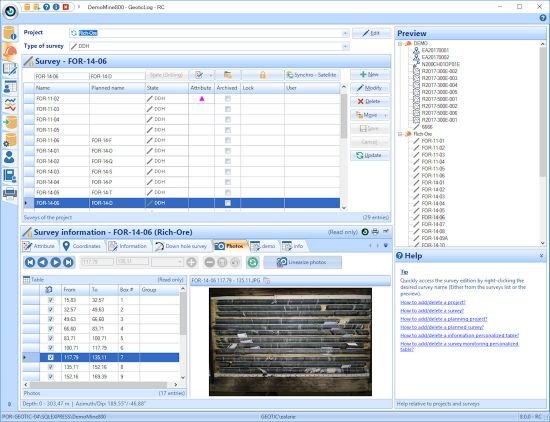
GeoticLog 8.2.22
File size: 186.4 MB
The GeoticLog application is used to input survey information. Its user-friendly interface greatly accelerates data input by allowing users to enter titles, summaries and even typical descriptions with the help of dictionaries. These dictionaries, which are edited by the users themselves, allow data to be validated when input, minimizing the need for subsequent corrections and ensuring exceptional data quality at all times.
The information is input and organized in a simple and logical way, making the work even easier.
The application also generates personalized reports according to your needs. Similarly, strip logs can be created.
The application includes a users' rights management interface to control data access and make data secure.
Data is saved in Access or SQL format and organized in an intuitive schematic diagram, making it easier to produce charts and thematic plans. These databases can then be used by GeoticGraph to create sections and plan views or they can even be exported to other applications.
GeoticLog database is directly linked to GeoticMine, which allow to go back and forth easily.
Lastly, modules for batch imports/exports, calculating composites, calculating adjusted structures, and QAQC and drilling core photo management integrate with your environment and greatly increase the application's potential.
Features
User-friendly and intuitive environment under Windows 10 or more
Multilingual (English, French, Spanish and Portuguese)
Relational database (Ms Access, SQL)
Complete validation of all data entries
Use of standard and personalized dictionaries
Descriptions for six geological levels plus RQD, magnetism, assaying, geochemistry and geophysics
Definition of an infinite number of coordinate systems
Zone weighted average calculations
Import/export of data
Export to GEMS
Printing of high quality logs
Creation of strip logs
Integration and linearization of drilling core photos
Management of assay certificates
Tracing of QAQC graphs
Personalized data tables
Integration and calculation of adjusted structures
Addition of calculated fields in the assay tables
Direct access to GeoticGraph's section creation wizard
Directly linked to GeoticMine
Planning and monitoring of a drilling campaign
HOMEPAGE
https://www.alsglobal.com/en/geoanalytics/data-generation/geological-data-collection-and-generation/GeoticLog
DOWNLOAD
We need your support!
Make a donation to help us stay online

Bitcoin (BTC)
bc1q08g9d22cxkawsjlf8etuek2pc9n2a3hs4cdrld

Bitcoin Cash (BCH)
qqvwexzhvgauxq2apgc4j0ewvcak6hh6lsnzmvtkem

Ethereum (ETH)
0xb55513D2c91A6e3c497621644ec99e206CDaf239

Litecoin (LTC)
ltc1qt6g2trfv9tjs4qj68sqc4uf0ukvc9jpnsyt59u

USDT (ERC20)
0xb55513D2c91A6e3c497621644ec99e206CDaf239

USDT (TRC20)
TYdPNrz7v1P9riWBWZ317oBgJueheGjATm
Information |
|||
 |
Users of GUESTS are not allowed to comment this publication. | ||