


Engipedia Topo Shaper 1.2.24.1020
Category: Apps (SEO/Marketing/Design)
- views: 92
- date: 19 November 2024
- posted by: voska89
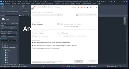
Free Download Engipedia Topo Shaper 1.2.24.1020 | 1.9 Mb
Transform Your Topography Instantly! The Engipedia Topo Shaper tool is designed to efficiently modify topography instances, including Toposolid and topography surface elements, using model lines. With this powerful tool, you can add additional topography points along selected model lines, shaping your landscape with precision and ease.
Key Features:
Wide Compatibility: Supports 10 versions of Autodesk® Revit®, from Revit 2015 to Revit 2025.
Demo Mode: Try out the tool for free with a limited demo option that allows you to divide lines into 2 segments. You can manually divide lines into more segments for enhanced flexibility.
Delete Topography Points: Easily delete existing topography points within polygons defined by the selected lines, allowing for greater control over your landscape modifications.
Add Points at Intersections: Automatically add additional points where your selected lines intersect with topography boundaries, ensuring your design integrates seamlessly with the existing terrain.
Delete Mode: Choose to delete existing topography points along selected lines, providing a straightforward way to clean up your design.
CSV Export and Backwards Compatibility: Save your topography points to a CSV file, enabling some level of backwards compatibility. Please note that importing CSV points may not recreate the original topography shape accurately if the original contained complex features, such as concave shapes or polygons with islands.
Supported Model Lines: All model lines are compatible, including lines, arcs, ellipses, curves, and NURBS. Please ensure that the selected model lines are not closed loops; otherwise, the tool will provide a warning and ignore them. For closed loops (such as circles and ellipses), they must be split into two or more parts using the Split Element tool in Revit.
Important Considerations: Topography is represented as a mesh object, so careful consideration of point distribution is crucial. Keep in mind that adding more points does not always result in better outcomes. Additionally, editing Toposolid elements may become slow as more points are added.
Save and Restore Your Work: An additional feature allows you to save the current state of the topography to a CSV points file. This enables you to easily restore the original state later using Revit's Massing & Site > Toposurface > Create from Import > Specify Points File tool. Please note that saved topography points are always recorded in meters.
Home Page-
https://apps.autodesk.com/DOWNLOAD LINK
Links are Interchangeable - No Password - Single Extraction
We need your support!
Make a donation to help us stay online

Bitcoin (BTC)
bc1q08g9d22cxkawsjlf8etuek2pc9n2a3hs4cdrld

Bitcoin Cash (BCH)
qqvwexzhvgauxq2apgc4j0ewvcak6hh6lsnzmvtkem

Ethereum (ETH)
0xb55513D2c91A6e3c497621644ec99e206CDaf239

Litecoin (LTC)
ltc1qt6g2trfv9tjs4qj68sqc4uf0ukvc9jpnsyt59u

USDT (ERC20)
0xb55513D2c91A6e3c497621644ec99e206CDaf239

USDT (TRC20)
TYdPNrz7v1P9riWBWZ317oBgJueheGjATm
Information |
|||
 |
Users of GUESTS are not allowed to comment this publication. | ||